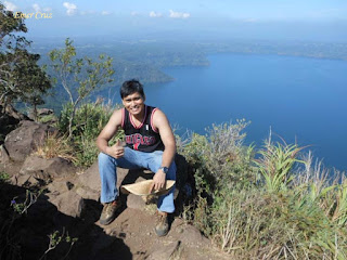
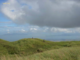
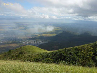
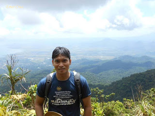
Tuesday, May 26, 2015

Lian Beach


Located in the municipality of Lian, Batangas, it was discovered in the 1950's as a great weekend destination by German tourists looking for a beach within the proximity of Manila.

Lian Beach is a quick get away from the Metro which is known for it's fine grain white sand, pristine and clear water that is teaming up with various marine and aquatic life e.g. sea urchin, starfish, coral reef, sea weeds to name a few. It is one of the most popular and accessible destination from Manila during summer which offers a picturesque view of sunset that faces the West Philippine Sea.

Pinoy Solo Hiker - Lian Beach

Pinoy Solo Hiker - Lian Beach

Pinoy Solo Hiker - Lian Beach

Pinoy Solo Hiker - Lian Beach

Pinoy Solo Hiker - Lian Beach


How to Get There:

1.) Take a bus bound to Nasugbu, Batangas (DLTB), their terminal is in LRT Buendia.
2.) Tell the conductor to drop you off in Lian Poblacion.
3.) You can then ride a Jeepney bound to Matabungkay

Wednesday, May 20, 2015

Mt Maculot Traverse (Rockies, Summit and Grotto)


Due to its close proximity from Manila, Mt. Maculot is one of the most popular day hikes near the Metro known for its overwhelming view and scenic landscape. It is located in the town of Cuenca, Batangas. A complete view of Taal Lake and volcano will keep you breathless upon reaching the Rockies' summit. It's no surprise that it is a "must climbs" for every mountaineer and adventure seeker. Mt Maculot has 3 popular trekking point: The Rockies 706 m (2316 ft), Summit 930 (3051 ft) and the Grotto. An average time of 2-2.5 hours trek from the jump point to the Rockies, then the traverse from the Rockies to the Summit is 1-1.5 hours; Summit to Grotto (there's a portion that you will have to rappel down through vertical rock walls).

One of the most scenic mountains, the trail does not encompass of a long walk, rather an almost straight ascent which will test the stamina and cardio most especially to those who are not used to hiking.

Pinoy Solo Hiker - Mt. Maculot

Pinoy Solo Hiker - Mt. Maculot

Pinoy Solo Hiker - Mt. Maculot

Pinoy Solo Hiker - Mt. Maculot

Pinoy Solo Hiker - Mt. Maculot

Pinoy Solo Hiker - Mt. Maculot

Pinoy Solo Hiker - Mt. Maculot

How to Get There:

1.) Take a bus bound to Lemery, Batangas (DLTB), their terminal is in LRT Buendia.
2.) Tell the conductor to drop you off in Cuenca Poblacion.
3.) You can then ride a Trike to Brgy Siete (Registration)
4.)You will be requested to register and take a guide with you for safety purposes.

Monday, May 18, 2015

Mt Kalisungan


It once played a vital part in Philippine history, as Mt. Kalisungan witnessed the twilight of Japanese occupation during WWII. Retreating Japanese soldiers take refuge in this mountain which is situated between the towns of Calauan, Nagcarlan and San Pablo City. The almost perfectly-shaped conical mountain has an elevation of  2493ft above sea level which is composed of two parts and has a total of 2000ft altitude gain from the jump-off point. The first part of the trail is mostly forested with slopes averaging 45 to 50 degrees. Then after more than an hour of ascending, one will reach the second part of the trail which is even steeper, composed of open grassland (predominantly cogon) and loose soil with slopes averaging between 50 to 60 degrees of pure assault until the summit.

Upon reaching the summit, one will be rewarded with a 360 degrees view of the surrounding landscape that includes: Mt Makiling, Laguna Lake, Talim Island (Mt Tagapo), Jala Jala Peninsula (Mt Sembrano), Sierra Madre ranges, the neighboring Mt Atimla, 4 of the 7 of the lakes of San Pablo City, Mt Banahaw, Mt Cristobal, and even Metro Manila can be seen from afar. It is usually climbed with Mt. Atimla for a twin day hike and some have even made it to a higher notch known as the "Laguna Penta" (Atimla-Kalisungan-Prinza-Imok and Obabis), making Kalisungan the highlight of the traverse because of its steepness and assault.

Pinoy Solo Hiker - Mt Kalisungan

Pinoy Solo Hiker - Mt Kalisungan

Pinoy Solo Hiker - Mt. Kalisungan

Pinoy Solo Hiker - Mt. Kalisungan

Pinoy Solo Hiker - Mt. Kalisungan

Pinoy Solo Hiker - Mt. Kalisungan

Pinoy Solo Hiker - Mt. Kalisungan

Pinoy Solo Hiker - Mt. Kalisungan

How to Get There:
1.) Take a bus bound to Sta Cruz, Laguna (DLTB or Greenstar), their terminal is in LRT Buendia.
2.) Tell the conductor to drop you off in Masapang.
3.) You can then ride a jeepney bound to Calauan/San Pablo tell the driver to drop you off in Brgy Lamot 2
4.)You will be requested to register and take a guide with you for safety purposes.

Mt. Makiling Traverse


Growing up in Laguna, I was always fascinated by the majestic beauty of Mt. Makiling- a dormant volcano named after Maria Makiling, believed to be the fairy guardian of the said mountain. It connects the province of Batangas and Laguna which spans to an estimated distance of 15 km. and has a total elevation of 3576 feet above sea level.

There are two known trails for Mt. Makiling, the common trail which is through the UPLB and the other one which is the Makiling Traverse popularly known as MakTrav. It starts in Sto. Tomas, Batangas and ends in UPLB making it a notch higher in terms of difficulty where it features a series of vertical walls, rope segments, mossy forest, narrow and steep trails and of course the notorious Limatiks. Through the years, it has become a favorite training ground among mountaineers who wish to hike Halcon or G2.

The Makiling Traverse starts in Brgy. San Miguel which passes several communities and a series of agricultural crops until reaching a dried river with a series of station markers to help hikers avoid confusion. From there on, it is a continuous ascent through a forested trail until reaching the Melkas Ridge which is the key highlight of the trail that offers a scenic view of Laguna and Batangas. After a few minutes of hike along the ridgeline, one will reach Peak 3 which is one of the summits. To continue with the traverse, one has to trek another 2 hours to reach Peak 2 which passes the Wild Boar trail characterized by a narrow and steep terrain that requires scrambling, body contortions and maneuvering through a series of obstacle along the path.

The summit of Peak 2 doesn't offer a 360 degrees view because it is covered with trees, wild bushes and shrubs. Only a tarpaulin stating that you are at the summit can be seen. The descent from the summit resembles some portions of Tarak ridge composed of forested trail where one has to cling to some roots and tree branches until reaching the Agila Base which is mostly flat surface. From there on, the trail leads to a cemented pathway all the way to UPLB Ranger jump off point.

There are some nice side trip that you can visit which includes: Flat Rocks and Mud Spring.

Pinoy Solo Hiker -Mt Makiling

Pinoy Solo Hiker - Mt. Makiling

Pinoy Solo Hiker - Mt. Makiling

Pinoy Solo Hiker - Mt. Makiling

Pinoy Solo Hiker - Mt. Makiling

Mud Spring
Pinoy Solo Hiker - Mt. Makiling

Pinoy Solo Hiker - Mt. Makiling


How to Get There: 
MakTrav
1. Ride a bus bound for Lucena or any Maharlika-bound bus
2. Tell the driver to drop off at Brgy. San Felix
3. Then ride a trike to Ecopark
4. Secure a guide

UPLB Trail
1. Take a bus bound for Sta Cruz, Laguna
2. Tell the conductor to drop you off in Olivarez/College.
3. You can then ride a jeepney bound to UP College Forestry
4. You can walk to the Registration area. One ID is required.