Monday, June 26, 2017

Animasola Island (Burias)

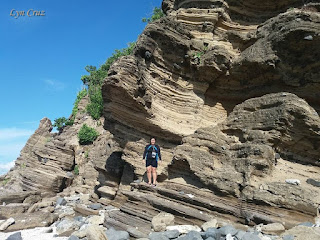
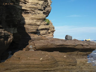
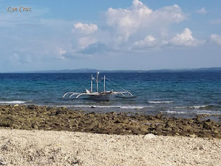
Animasola Island is part of the Burias group of islands which is located in Masbate of the Bicol Region. It is considered among the most popular islands in Burias and was named as "Animasola" which means "lonely soul" in Latin which pertains to those souls that are in Purgatory, but for the tourists who visited the place it's all amazement for the wondrous work of art that nature has to offer.

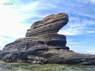
It is composed of stunning rock formations through a number of geological periods which is truly a nature's picturesque masterpiece. Some experts says that the rocks are actually corals and were formed by the incessant lapping of tidal waves against the shore through the centuries and is commonly was compared to "Kapurpurawan" rock formations of Ilocos Norte.

According to my sister's account there is also a small pool/lagoon where one can cool swim and immerse on one side of the island, 

Pinoy Solo Hiker - Animasola Island (Burias)

Pinoy Solo Hiker - Animasola Island (Burias)

Pinoy Solo Hiker - Animasola Island (Burias)

Pinoy Solo Hiker - Animasola Island (Burias)

Pinoy Solo Hiker - Animasola Island (Burias)

Pinoy Solo Hiker - Animasola Island (Burias)

Pinoy Solo Hiker - Animasola Island (Burias)

Pinoy Solo Hiker - Animasola Island (Burias)

Pinoy Solo Hiker - Animasola Island (Burias)

How to Get There:
1. Ride a bus bound for Naga City
2. From Naga, ride a jeepney or van to Pasacao Port which will take about thirty minutes to one hour. 
3. Once in Pasacao, a two-hour boat ride will take you to Burias Island.
***My sister joined an organized tour and it was based on her account that this write-up was made.
Monday, June 19, 2017

Why I Hike?

Pinoy Solo Hiker

At some point in your life you will get bored of your usual self, when that day comes step out of your comfort zone; and live your life from a different perspective. Travel and explore the world around you, go places that you've never been to. Meet new people, learn new things and culture, try new food and get lost to find your inner self. There are so many things you can learn from traveling compare to just reading textbooks.

Ever since I started blogging, friends and colleagues alike always asked me with this simple question "Why do you hike?" For me, hiking is not just taking great pictures and appreciating nature at it's finest, it is my way of relaxing whenever I feel exhausted and tired of my routinary life. Hiking and traveling in general is my self discovery, passion and inner peace which made me discover my love for writing. Traveling let's you see how little you are in this vast world yet still significant in God's magnificent creation.

Do the things that you loved the most while you are still young. Money and riches can be earned but free time, strength and opportunities to go places while we are young cannot be the same as when you age. Time flies easily, 30 years from now we may have all the free time in the world to do everything we want, to go places we've never been yet we may not have the same strength and vigor we once had during our younger years. We can just look back and wished we've done what we should have done.

Sunday, June 18, 2017

Mt. Pulag

The third highest peak in the Philippines and the highest in Luzon which is considered as one of the coldest places in the country that rises to an altitude of 9600 ft. above sea level. There are several trails that leads to the summit among which are the "Akiki" trail known as the killer trail, it is notorious for its steep ascent and high altitude gain. The "Tawangan" trail also known as the "bloody trail" because of the abundant presence of "limatiks" or blood leeches that can be found along the trail. The "Ambaguio" trail which starts from the neighboring province of Nueva Viscaya and traverses to the province of Benguet usually takes days to finish and lastly, the "Ambangeg" trail which is the easiest among the trails and has become the common trail even for those with no hiking experience due to it's gradual ascent and easy trail.

Mt. Pulag is considered a sacred place for the indigenous Ibaloi, Kalanguya and Kankanaey people which they consider it as the "playground of the gods", they believe that the spirits of their ancestors live, rest, and play year-round in the said mountain. They perform Canaos and many other rituals and sacrifices to lead them there. Pulag is believed to be the eternal destiny where their ancestors will dwell and be reunited with all those who went ahead of them. In the local dialect, "Pulag" was derived from the word 'Pulog" which means bald that describes the summit of the mountain composed of flat grassland and dwarf bamboos.

According to the DENR, Mt. Pulag has one of the richest biodiversity in the country, having vast forests full of pines, moss, and grass which offers a picturesque view known for its sea of clouds and sunrise. It is the natural habitat of the endemic "Dwarf Bamboo" and the "Benguet pine" which dominates the areas of Luzon tropical pine forests found on the mountainsides. Among its native wildlife are 33 bird species and several threatened mammals such as the Philippine Deer, Giant Bushy-Tailed Cloud Rat and the Long-Haired Fruit Bat, it is the only place that hosts the four cloud rat species.

I didn't have the chance to witness the famed sunrise because of the bad weather that we experienced, perhaps I'll come back again soon.


The Mossy Forest 


How to Get There:
1. Ride a bus bound for Baguio City (Victory Liner)
2. From Baguio City head to the bus terminal at Old Slaughterhouse
3. Take A-Liner bus bound for Kabayan
4. Go to the visitors center to register.
5. From the Ranger Station ride a "habal-habal"
** Alternatively, for a larger group one can rent a chartered jeep bound for Sitio Ambangeg

** I joined an event organized by Traveling Adventure

Wednesday, June 14, 2017

Fortalez Beach

Situated in Maricaban Island in the municipality of Tingloy, Batangas. According to the resort owner, "Fortalez" beach got its name from the Spanish word "Fortaleza" which means stronghold and last refuge after his father chose this as his stronghold when he retired in the mid 90's. 

The beach is composed of long-stretched of coastline that has fine grain to pebbled grains of cream-white sand. Several rock formations can also be seen along the stretch of the shore teeming with pristine and clear water making it ideal for snorkeling. Fortalez Beach is truly a must visit place, a hidden gem in the province of Batangas that is not crowded with tourists.


Pinoy Solo Hiker - Fortalez Island

Pinoy Solo Hiker - Fortalez Island

Pinoy Solo Hiker - Fortalez Island

Pinoy Solo Hiker - Fortalez Island

Pinoy Solo Hiker - Fortalez Island

Pinoy Solo Hiker - Fortalez Island

Pinoy Solo Hiker - Fortalez Island
Photo Credit: Michael

How to Get There:
1. From Manila, ride a bus bound for Batangas City Grand Terminal
2. Ride a jeep bound for Anilao Port
3. Then ride a passenger boat bound for Maricaban
(You can also rent a private boat 2500/10px)

Monday, June 12, 2017

Squat Thrust for a Total Body Workout

When I was a cadet in a military school, I always loathed doing the "Squat Thrust" also known as "Burpees" - the only difference is that Burpees are more challenging because of the jump at the end. It was given as a form of punishments not just a one-count repetition but almost infinite counts to the point that your body feels exhausted making you gasp for more air.

According to Oxford Dictionary Online, Burpee exercises was named in the 1930s after the American physiologist Royal H. Burpee, who developed the "burpee test". It was further popularised in 1944 when it was adopted as one of seven exercises used by the US Army in its new toughening up programme which is I described as hellish and exhausting.

Now I realized the reason why the armed forces, fitness boot camps, cross fit trainers and martial arts classes around the world incorporate it into their training regimens. Simply because it is a full body exercise used in strength training and as an aerobic exercise which improves aerobic endurance, strengthens both muscles and bones, create lean muscle mass that raises the metabolism and, of course, help keep you fit and healthy.

When done correctly and arduously, it combines the feelings of breathlessness, elevation of the chest wall, forced expiration, higher heart rate and the legs will have a feeling of a burning sensation due to the increase of lactic acid. With each repetition, it forms the chest, arms, calves, front deltoids, thighs, hamstrings, abs and most importantly strengthens your cardio endurance. I personally used this exercise whenever I have upcoming major hikes that requires full assault and seemingly endless trails.


***The blogger do a 3 sets of squat thrust 25 repetition per day.

Tuesday, June 6, 2017

Mt. Sembrano

Situated between the boundaries in the towns of Jalajala and Pililla in Rizal province and the town of Pakil in Laguna. Mt. Sembrano is located at the helm of Jalajala peninsula along the shore of Laguna de Bay and is surrounded by the lake on three sides. Along with Talim Island, this mountain forms the southeastern rim of the Laguna Caldera.

It used to have NPA insurgents in the past, but now it has become a popular hiking destination near the Metro due to its accessibility and scenic views. The first part of the trail passes through a cemented pathway which eventually leads to a rocky portion with a gradual ascent, which then leads to the Manggahan campsite (Mango trees abound in the area) and can accommodate more than 20 tents. 

From there on, the trail becomes steeper that is akin to Tarak ridge but is much shorter which eventually leads to an open grassland slope composed of tall grass and steep loose soil. There are two summits, the first summit which is known as The North Peak is the first high point and many hikers who stay overnight prefer to camp here and after a few minutes of trekking leads to the South Peak or the known summit. The trail has a total of 1980 ft. altitude gain from the jump off to the summit and has a total distance of 11 km. through the backtrail.

Upon reaching the South Peak (summit), one will be rewarded with a scenic view of the Laguna Lake, Sierra Madre ranges, Talim Island, Banahaw Trilogy, Mt. Makiling and the distant Mt. Arayat can also be seen on a clear day.

Pinoy Solo Hiker - Mt. Sembrano

Pinoy Solo Hiker - Mt. Sembrano

Pinoy Solo Hiker - Mt. Sembrano

Pinoy Solo Hiker - Mt. Sembrano

Pinoy Solo Hiker - Mt. Sembrano

Pinoy Solo Hiker - Mt. Sembrano

Pinoy Solo Hiker - Mt. Sembrano

Pinoy Solo Hiker - Mt. Sembrano

How to Get There:
1. Ride a jeep bound for Tanay, Rizal.
2. Once in Tanay ride a jeep bound for Pililia and tell the driver to drop you off in Brgy. Malaya to register and secure a guide

*** I joined an event organized by Laagan Outdoors.

Monday, June 5, 2017

Sombrero Island (Burias)

Sombrero Island is part of the Burias group of islands which is located in Masbate of the Bicol Region. It is considered among the most popular islands is Burias and was named as "Sombrero" which means as hat because it resembles a hat-shape features. According to my sister's account there are some spot ideal for diving which the locals call as "Batok".

The whole island is surrounded by a long stretched of powdery white sand beaches, crystal-clear turquoise waters of the Pacific Ocean, unspoiled natural resources and a sandbar can also be seen during low tide which offers a truly remarkable environment.

Several nipa hut cottages can be rented or pitch a tent if one wishes to stay for an overnight.

Pinoy Solo Hiker - Sombrero Island

Pinoy Solo Hiker - Sombrero Island

Pinoy Solo Hiker - Sombrero Island

Pinoy Solo Hiker - Sombrero Island

Pinoy Solo Hiker - Sombrero Island

Pinoy Solo Hiker - Sombrero Island

Pinoy Solo Hiker - Sombrero Island

How to Get There:
1. Ride a bus bound for Naga City
2. From Naga, ride a jeepney or van to Pasacao Port which will take about thirty minutes to one hour. 3. Once in Pasacao, a two-hour boat ride will take you to Burias Island.
***My sister joined an organized tour and it was based on her account that this write-up was made.

Saturday, June 3, 2017

Mt. Purgatory

It was named by an American logging supervisor as "Mt. Purgatory" because of the harsh working conditions in the area which is comparable to that "being in purgatory". But despite it's ominous name, Mt. Purgatory together with other peaks along the traverse trail makes it a wonderful hiking experience in the Cordillera region. 

The complete Purgatory-Mangisi traverse has a total of (more or less) 25 kilometers which passes seemingly endless mossy forest and myriads of pine trees. The trail uses the old rough roads and well-established footpaths through rolling terrains of peaks and even villages which offers hikers a breathtaking views of Benguet and nearby Cordillera mountains.

Because of its mesmerizing beauty and soothing breeze of Benguet, hikers will feel not as if they are in purgatory, but rather they are in "Cloud 9".

Pinoy Solo Hiker - Mt. Purgatory

Pinoy Solo Hiker - Mt. Purgatory

Pinoy Solo Hiker - Mt. Purgatory

Pinoy Solo Hiker - Mt. Purgatory

Pinoy Solo Hiker - Mt. Purgatory

Pinoy Solo Hiker - Mt. Purgatory

Mossy Forest
Pinoy Solo Hiker - Mt. Purgatory

Pinoy Solo Hiker - Mt. Purgatory

Pinoy Solo Hiker - Mt. Purgatory


How to Get There:
1. Ride a bus bound for Baguio via Victory Liner
2. Once in Baguio, you can take a chartered jeep to Bokod Municipal/Tourism Office