Monday, October 14, 2019

The Historic Island of Corregidor


Located about 48 km. of Manila (inland), the word Corregidor comes from the Spanish word “corregir,” which means to correct. According to some historians, during the Spanish time all ships that enters Manila Bay were required to stop and have their documents checked and corrected, the island was called then called “Isla del Corregidor” (Island of the Correction). Another version claims that the island was used as a penitentiary or correctional institution by the Spanish and came to be called “El Corregidor” or Mile-Long Barracks. Corregidor Island is flanked by several islands (Caballo islands, Carabao Island and El Fraile Island) that formed the harbor defenses of Manila.

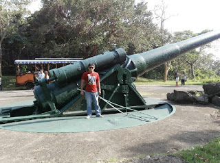
Contrary to popular belief, Corregidor is actually a part of Cavite with a size of 5 sq. km. that is shaped like a tadpole and the highest elevation of the island is about 650ft above sea level. Corregidor was fortified with several artillery and ammunition magazines to defend the entrance of Manila Bay and the City of Manila from attacks by enemy warships. 

During World War II, Corregidor played an important role during the invasion and liberation of the Philippines from Japanese forces. It was actually the second most heavily bombarded island next to Malta. The ruins left on the island serve as a military memorial to American, Filipino and Japanese soldiers who served and lost their lives on the island. 

There are several point of interest inside Corregidor among which are: Pacific War Memorial, numerous gunneries, Ruins, and the Malinta Tunnel, which served as a supply depot, hospital and MacArthur’s headquarters.

Corregidor tour is indeed a must for every Filipino. It is an effective reminder of the sacrifices of soldiers who fought for our freedom.

Pinoy Solo Hiker - Corregidor Island

Pinoy Solo Hiker - Corregidor Island

Pinoy Solo Hiker - Corregidor Island

Pinoy Solo Hiker - Corregidor Island

Pinoy Solo Hiker - Corregidor Island

Pinoy Solo Hiker - Corregidor Island

Pinoy Solo Hiker - Corregidor Island

Pinoy Solo Hiker - Corregidor Island

How to Get There:
1.) The best and most efficient way of going to Corregidor is thru a group tour.
2.) Go to the Esplanade Seaside Terminal located near MOA, you can book a tour at Sun Cruise, tour also includes a buffet meal..

Saturday, September 14, 2019

Alligator Lake


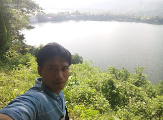
Alligator Lake is a freshwater crater lake-filled maar which is situated along the southern shore of Laguna de Bay in Los Banos. The Alligator Lake protrudes out of the shore of the larger lake and they are separated by a crater rim from the surrounding Laguna de Bay which is a piece of land that is about 40-meter (130 ft).

The lake was named Alligator Lake since the Spanish colonial period when it was known as Laguna de los Caimanes (Lake of Alligators or Alligator Lake) where a great number of Alligators used to live in its waters, thus it was named after.

Resorts around the lake offers water activities such as Kayaking, Paddle Boat and Banana Boat Ride. The Lake itself boasts of clear water due to low nutrients which resulted in low Algae production. A noticeable "cut" on the hill makes a picturesque distinction around the lake that attracted my attention. The highest point on the quarried portion of the hill is approximately 210 feet and is composed of almost 200 steps. The hill had also became the nesting ground for thousands of Bee Eaters.

Pinoy Solo Hiker - Alligator Lake

Pinoy Solo Hiker - Alligator Lake

Pinoy Solo Hiker - Alligator Lake

Pinoy Solo Hiker - Alligator Lake

Pinoy Solo Hiker - Alligator Lake

Pinoy Solo Hiker - Alligator Lake
As seen from Mt Makiling's peak 2

How to Get There:
1.) Take a bus bound to Sta Cruz, Laguna (DLTB or Greenstar), their terminal is in LRT Buendia.
2.) Tell the conductor to drop you off in Bagong Kalsada.
3.) You can ride a Trike or walk towards Alligator Lake which is 20-30mins.

Sunday, August 11, 2019

Mt Kalawitan Circuit

Situated in Mt. Province which is located in the heart of Cordillera, Mt. Kalawitan stands at 8905ft above sea level and is considered as the 10th highest peak in the Philippines. This blog post was already long overdue, we hiked last April 28, 2018 via the "Kalawitan Circuit" which according to our guide is more challenging than the backtrail and the traverse. The circuit trail has a total of 35km distance, 17km from the jump-off point to reach the summit and the traverse via the circuit trail back to jump-off is 18km. As I have hiked Kalawitan Circuit and Namandiraan Traverse were I was both part of the lead group, I can honestly say that Kalawitan Circuit is more challenging. It has steeper rolling terrain which are all assault that leads to the summit and has a total elevation gain of 5350ft (4820ft jop to summit).

The name Kalawitan have originated from Kankakeny word "Kalawit" which means to climb, true enough Mt. Kalawitan is among the most challenging mountains in Cordillera alongside Amuyao and Napulauan. The initial part of the trail commences through a cemented pathway (Golden farm Resort) which then leads to a myriad of pine forests until reaching the first campsite where we regrouped and had our lunch. From there on, the trail becomes steeper which leads to a very thick mossy forest characterized by steep rolling terrains, infested with limatiks which only proves of its rich biodiversity. Since our hike was a circuit trail our guide told us that it was advisable to camp at the summit and not at the prior campsite which was still an hour away and usually used by those who go on a backtrail.

After seven grueling hours of hiking at the lead group where I followed the guide at his pacing, we finally reached the summit. It was raining that time, and the whole place were covered with fog and limatiks were everywhere but thank goodness they were not that aggressive. After minutes my teammates started to arrive, we then set our camp, had our dinner and socials afterward amidst the freezing cold. 

I have been to Amuyao, Napulauan and Kalawitan and I can say that the latter is the coldest among the three considering that we did our hike during the month of April which was recorded at 7degrees. Amuyao (December @10degrees) and Napulauan (February @9 degrees) hike all were recorded at 1am.

The following day, I woke up early just in time for the sunrise where the whole place was still covered by a thick mist. Mt. Kalawitan's summit is like a plateau characterized by a summit marker, dwarf bamboos, and overgrown trees which makes a 360degree view, not a possibility. But by sheer patience and determination, one can still piece together images from various vantage points by stepping on a tree, I witnessed the magnificent sea of clouds which were also shared by the neighboring Amuyao and Napulauan on the other side.

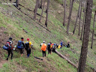
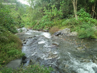
After we had our breakfast, we started the descend via the traverse circuit trail characterized by a very moist and steep inclination of 60-70 degrees passing through a very thick jungle with more aggressive limatiks as compared to the backtrail. The trail at that time was still semi exploratory with overgrown grass as we were among the first few groups who did the circuit trail for a total of 18km to reach the resort (jop) from the summit. The succeeding part of the trail then passes rolling terrains which consist of pine forest, river crossing, rice paddies and hanging bridge. Then the final phase of the circuit trail is a 500ft ascent to a cemented pathway which then leads to the stair path where the backtrail and circuit trail separates.

Pinoy Solo Hiker - Kalawitan Circuit
The tree at the summit which serves as the viewing deck

Pinoy Solo Hiker - Kalawitan Circuit
Sea of clouds

Pinoy Solo Hiker - Kalawitan Circuit
L-R: Derrick, Emer, Bien, Memz, Mojo, Jumong
Rachel Anne, Katrina, Joward, Deesh, Jetro

Pinoy Solo Hiker - Kalawitan Circuit
Tropang Kalawitan

Pinoy Solo Hiker - Kalawitan Circuit
Trees at the summit
The lead group while waiting sa mga ksama nmin

Pinoy Solo Hiker - Kalawitan Circuit
The thick Mossy Forest

Pinoy Solo Hiker - Kalawitan Circuit

Pinoy Solo Hiker - Kalawitan Circuit
The blogger with our rock star guide

Pinoy Solo Hiker - Kalawitan Circuit
Pine trees at the descent

Pinoy Solo Hiker - Kalawitan Circuit
Ferns and Pine trees

Pinoy Solo Hiker - Kalawitan Circuit
One of the first few groups to do a circuit trail

Pinoy Solo Hiker - Kalawitan Circuit
While waiting sa mga kasama, hokage pose muna.

Pinoy Solo Hiker - Kalawitan Circuit

Pinoy Solo Hiker - Kalawitan Circuit

Pinoy Solo Hiker - Kalawitan Circuit
River crossing

Pinoy Solo Hiker - Kalawitan Circuit
Rice Paddies which signifies the last part of the trail

Personal Rating: 7/9 (Circuit trail) and 5-6/9 (Backtrail)
***I joined an event organized by Deesh Tan and Rachel Ann of Lunsulan Adventures.
Thank you sa mga nkasama ko sa hike na ito , kay Sir Bienvenido na nagpasilong sa amin s knyang tent, maraming salamat brod. Sa masayang tawanan na hatid ng mga Bagani Moutaineers na sina Sir Memz Moradillo, Joward, Jetro, Jumong, Derrick (birthday nya that time), Mojo at Katrina.

Photo credits nga pla sa mga groupies na pictures nmin, pag aari yun nila Memz Moradillo at Deesh Tan, kinopya ko nlang sa GC.

Friday, August 2, 2019

Zark's Burger


When it comes to great burgers at an affordable price, Zark's is the first thing that comes to my mind. I religiously pay Zark's a visit mostly during payday as it became my regular comfort food. The name of the burgers in Zark's menu are categorized into two: The Minor League and The Major League. They used well striking and quite catchy names that I myself find it humorous that includes: Strikeout, Homerun, Tapout, Three-Pointer, King James, Stonecold, Tombstone and so on. But what made me laugh so hard is the Floyd Chicken Burger. I said to myself, if the inspiration of this burger is the badass Floyd Mayweather, then it serves him well. 

The waiter told me that they have this challenge - finished the Tombstone or Jawbreaker Burger in just 10 minutes and it's free, well I am not interested in the challenge even if it is free, I am not a competitive eater so I'd rather savor what I'm eating.

I usually order Mushroom Garlic Rice Meal along with my favorite Zark's Ultimate Burger. It is filled with cheese sauce, sauteed mushrooms and bacon. Back then (about 7years ago) , their burgers were not that good when I had my first Zark's experience in their first resto in Taft. I could still recall their beef patty which breaks easily, also the buns that they used were just like any buns sold in local bakeries. Today, it's a little bit different, the patties are more crunchy yet tender, same with their buns that has improved greatly. Zark's ultimate burger is my classic favorite which is richly garnished with bacon strips that are haft cooked or caramelized, it is much better if it's crunchy. 

I also ordered the Three-Pointer burger, it uses three kinds of cheese: mozzarella, cheddar and cheese sauce which is worth it for its price. As a burger lover, whenever I am in Zark's all  can I think of is to munch on the mouth-watering meal everytime it is served right in front of me. 

Pinoy Solo Hiker - Zark's Burger
Three-Pointer Burger


Pinoy Solo Hiker - Zark's Burger
Mushroom Garlic Rice Meal
The "Tombstone" challenge 


Rating: 
7 out 10

Sunday, July 28, 2019

Entablado Cafe

Whenever you are in Los Banos, Laguna then Entablado is one of the most recommended places to dine and have a sip of coffee. Though the place is a little bit small which can only accommodate between 20-25 people at a time, but then again it has a nice ambiance and still cozy at its own right.

The must-try among their menus are their "TinaPizza" and "TunaPasta", which is richly garnished with 'Tinapa" (smoke fish) and melted cheese something that you don't see every day. And of course, their other specialties include Coffee brews from Kalinga and Dark Choco Mint Frappe.

Prices are affordable, making it a favorite "meeting place" for some students to study and hang out while enjoying a cup of coffee and listening to acoustic performers. Sometimes it's none other than Ebe Dancel of Sugarfree who performs in the "Entablado" (center stage) and also owns the place. 

Tuna Pizza and Tuna Pasta

Pinoy Solo Hiker - Entablado Cafe

Pinoy Solo Hiker - Entablado Cafe
I had sore eyes that time

Pinoy Solo Hiker - Entablado Cafe
Kalinga Coffee

Pinoy Solo Hiker - Entablado Cafe

Pinoy Solo Hiker - Entablado Cafe

Pinoy Solo Hiker - Entablado Cafe
Ebe Dancel of Sugarfree

Location: Ground Floor, Vega Center Los Banos, Laguna (beside UP Gate)

Friday, July 5, 2019

Mt. 387 (Ghost Rock)

Situated in Caranglan, Nueva Ecija; Mt 387 is part of Talavera Watershed Forest Reserve along the Caraballo mountain ranges with a land area of 387.9 hectares, thus it is where it got its name. It is also known to the locals as "Batong Amat" in the local dialect which means "Ghost Rock" because the remains of those who died during World War 2 were buried most especially the Japanese soldiers. The whole place also served as a barracks and Japanese camp and there where instances that rusted armaments can still be dug up. 

To some, Mt 387 was also known as the "Chocolate Hills of North", well honestly I don't see any resemblance at all, it looks like more of an uneven "Chocolate Hills" and the numbers of slopes are quite few to compare. My apologies but I don't agree with some bloggers or these promotional ideas. For me, it is already beautiful and awesome in its own right, no need to compare it with another landmark just to get attention whatsoever. 

The 387 hectares of the mountain range was awarded to "Kalinga sa Kalikasan ng Puncan" (KAPUNCAN) headed by Sir Roy Manuzon. Their group have agreed with DENR to protect and preserve the land area, thus each visitors (hikers and travellers) alike are requested to plant a tree each time they hike Mt. 387 which is part of the reforestation initiatives.

The initial part of the trail is forested until reaching an open grassland until it leads to a huge pile of rocks known as the "Ghost Rock" where the remains of those who died during WW2 were buried. Then another 5 minutes of trekking will lead to the famous landmark known as the "Lover's Tree", it is the only tree in the vast open grassland. According to some local legend that circulated among the outdoor community "Whoever climbs the said tree will be lovers or they will find their lover". The summit is characterized by a ridge that offers a 360-view of the Caraballo Mountain Ranges.


Pinoy Solo HIker - Mt 387
Dubbed as the "Chocolate Hills of the North"

Pinoy Solo HIker - Mt 387
Team Una: Emer, JC & Michael

Pinoy Solo HIker - Mt 387

Pinoy Solo HIker - Mt 387
Batang Amat aka Ghost Rock

Pinoy Solo HIker - Mt 387
Team Una @ Ghost Rock

Pinoy Solo HIker - Mt 387

Pinoy Solo HIker - Mt 387
Tree Planting

Pinoy Solo HIker - Mt 387

Pinoy Solo HIker - Mt 387


Pinoy Solo HIker - Mt 387
Lover's Tree

Team Una Family


Pinoy Solo HIker - Mt 387
Team Una Family

How to Get There:
1. Ride any bus bound to Tuguegarao.
2. Alight in Km 175 Brgy Puncan in frfont of Iglesia Ni Cristo
3. Or ride a bus bound to San Jose, Nueva Ecija.
4. Once in San Jose, you can ride a trike to the jop.
Sir Roy Manuzon (09175712152)

***I joined an event organized by Team Una