Saturday, March 25, 2017

National Arts Center (Makiling)

The National Arts Center is a building complex situated in Mount Makiling Forest Reserve, Los BaƱos, Laguna. The establishment was inaugurated in 1976 by First Lady Imelda Marcos for aspiring young artist. It serves as a boarding school for artistically gifted Filipino secondary school students that have various facilities which include cottages that serve as classrooms and dormitories.

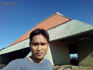
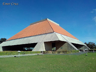
One of the most iconic structure is the amphitheater known as the Tanghalang Maria Makiling or the NAC Center which has an audience capacity of 1,800 people. It is a red-roofed structure (without walls) that is visible from the nearby towns of Laguna.

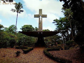
The highest point in National Art Center has an altitude of 1500 ft. above level and has a total of 1010 ft. altitude gain from UPLB (Auditorium). On the way up NAC one will pass by St. Marc's Chapel, it is a chapel without any walls; set against a forest backdrop. Upon arriving at the amphitheater one will be rewarded with a spectacular view of Laguna Lake, Talim Island, Crocodile Lake (a lake within a lake), and the surrounding towns of Laguna.

Pinoy Solo Hiker - National Arts Center

Pinoy Solo Hiker - National Arts Center

Pinoy Solo Hiker - National Arts Center

Pinoy Solo Hiker - National Arts Center

Pinoy Solo Hiker - National Arts Center

Pinoy Solo Hiker - National Arts Center

Pinoy Solo Hiker - National Arts Center

Pinoy Solo Hiker - National Arts Center

Pinoy Solo Hiker - National Arts Center


How to Get There:
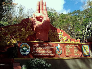
1. When going to UPLB you can use the Jamboree Road and you will pass by the Boy Scouts of the Philippines marker. You will then see a welcome arch that says "National Art Center"

Thursday, March 23, 2017

Mt. Ugo Traverse

One of the most popular hiking destination in the Cordilleras, Mt. Ugo stands at altitude of 7054 ft. above sea level. The traverse trail starts from Kayapa, Nueva Viscaya has a total of 3420 ft. altitude gain that leads all the way to the summit.

Mt. Ugo has a rich history which dates back during Spanish era. According to the locals, the word “Ugo” was derived from "Ibaloi" word which means "to cut the neck/behead" someone, it also akin to the word "Pugot" (behead). Native people who used to lived in the mountains defend their lands from Spanish and American invaders that were made captives and eventually beheaded.

In 1987 an airplane crashed into one of Mt. Ugo's slope that instantly killed 50 people onboard the plane. The infamous incident paved the way for the site's exploration that created established trails to the summit. Since then, many mountaineers were attracted to explore the traverse trail which crosses two provinces, namely: Nueva Viscaya and Benguet.

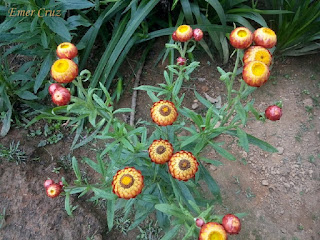
The trail was an assault of different levels, all were manageable but it wasn't easy at all. We started our trek through a plight of stairs making it exhausting to the legs, it was a full assault until reaching the first village. From there on, the trail was a established pathway with minimal ascent. Myriads of pine trees are present all throughout the 32 km. trail, the different Flaura and Faunas  that thrives only on cold weather makes Mt. Ugo's trail truly remarkable. As we continue our hike we passed by a several areas of Mossy forest which also includes the one before the summit. 

The final leg of the trail to the summit has no trees to cover from the sun. The trail was steep comprising of full assault and some portions has loose soil/rocks. It was a good thing that the cool breeze of Benguet compensates the scorching heat of the trail making it relaxing and soothing for hikers. Upon reaching the summit one will be rewarded with a picturesque 360 degree view of the surrounding landscape which includes Cordillera mountains Mt. Pulag, Mt. Singakalsa, Mt. Tabayoc, Mt. Napalauan, Mt. Sto. Tomas and even Baguio City. Several wild berries can be seen at the summit and a marker can also be found stating the total elevation of Mt. Ugo.

From the summit, one has to descent through a very steep pine forest to complete the traverse trail to Itogon, Benguet. And the final leg of the descent, one will passed the hanging bridge which commenced the end of the trail.

There are several water stations (two water stations on the ascent and two on the descent) and stores (three stores on the ascent and ne on the descent) that can be found along the trail.

We were able to complete the 32 km. day hike traverse in less than 12 hours (with rests included).

Pinoy Solo Hiker - Mt. Ugo Traverse

Pinoy Solo Hiker - Mt. Ugo Traverse

Pinoy Solo Hiker - Mt. Ugo Traverse
Charlie, Alvin, JC, Emer, Ian & Fatima

Pinoy Solo Hiker - Mt. Ugo Traverse

Pinoy Solo Hiker - Mt Ugo Traverse

Pinoy Solo Hiker - Mt. Ugo Traverse

Pinoy Solo Hiker - Mt. Ugo Traverse

Pinoy Solo Hiker - Mt. Ugo Traverse

Pinoy Solo Hiker - Mt. Ugo Traverse
The summit view

Pinoy Solo Hiker - Mt. Ugo Traverse
Kayapa, Nueva Viscaya

Pinoy Solo Hiker - Mt. Ugo Traverse
Mountain Goats

Pinoy Solo Hiker - Mt. Ugo Traverse


Flora and Fauna along the trails

Pinoy Solo Hiker - Mt. Ugo Traverse
Mini Mossy Forest

Pinoy Solo Hiker - Mt. Ugo Traverse

Pinoy Solo Hiker - Mt. Ugo Traverse

Pinoy Solo Hiker - Mt. Ugo Traverse

Pinoy Solo Hiker - Mt. Ugo Traverse

Pinoy Solo Hiker - Mt. Ugo Traverse

How to Get There:
1. Ride a bus bound for (Aritao) Bambang, Nueva Viscaya
2. Rent a chartered jeep bound for Kayapa, Nueva Viscaya
3. Register and secure a guide.

To Baguio:
1. Once you passed the Itogon bridge, it commenced the end of the trek.
2. You can ride a chartered jeep to take you to the Brgy Hall.
3. Proceed to Baguio via a chartered jeep

***I joined an event organized by Diwata RR Tours
***I recommend Kuya Rizal Langad as a guide.
Sunday, March 12, 2017

Tarak Ridge

Tarak Ridge is one of the many peaks that can be found in Mount Mariveles which is located in Bataan and has a total elevation of 3700 ft. above sea level. Locals named the ridge as "Tarak" which is an amalgamation of “Tabak” (hunting knife) and “Tarik” (steep) which is composed of many peaks. 

It was actually my first hike since I've recovered from Chikungunya three days earlier, yet the joint pain and muscle weakness hounded me before the hike, I was so thankful for the pain reliever that eased the pain and enabled me to endure a total of 18 km trail. 

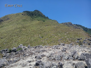
The trail that leads to the summit is composed of three parts: the first part is a gradual ascent from the jump off point that passes through a forested trail and some rocky portions until reaching the Papaya River. The second part of the trail is composed of pure assault which has a rope segment, steep slopes that requires technical climbing through rock walls and roots. The trail is densely forested until reaching the third part of the trail which marks the ridge line that is composed of grassland, rocky terrain, steep cliffs and jagged rocks that offers a dramatic landscape which has attracted mountaineers and nature lovers alike.

From the ridge line, one has to trek another 30 minutes in order to reach Tarak's summit which is composed of a total 600 ft. ascent. Upon reaching the summit, one will be rewarded with a picturesque view of  nearby peaks, Bataan, Manila Bay, Corregidor Island as well Cavite. 

Pinoy Solo Hiker - Tarak Ridge

Pinoy Solo Hiker -Tarak Ridge

Pinoy Solo Hiker -Tarak Ridge

Pinoy Solo Hiker -Tarak Ridge

Pinoy Solo Hiker -Tarak Ridge

Pinoy Solo Hiker -Tarak Ridge

Pinoy Solo Hiker -Tarak Ridge

Pinoy Solo Hiker -Tarak Ridge

Pinoy Solo Hiker -Tarak Ridge

How to Get There:
1. Ride a bus bound to Mariveles, Bataan (Bataan Transit/ Five Star)
2. Alight in Alas-asin, Mariveles (tell the conductor to drop you off in Tarak Registration)
3. Register in Alas-asin Brgy. Hall

** I joined an event organized by Adventurous People