Saturday, September 30, 2017

Why We Are Team Una?


"Team Una" is composed of dynamic and professional individuals whose interest in the outdoors has taken them to established the group which means "First". They randomly met in previous hikes as solo joiners, then the vision of Team Una came into existence with the same ideals and love for the outdoors.

As a group, we have this motto: "Sama-sama tayong aakyat sa bundok at sama-sama din tayo bababa bilang magtrotropa. Walang Iwanan" and firmly believe friendship and relationship matters most, because we are not a profit-oriented group. 

We believe that the joiners should be prioritized in the event and that their satisfaction is of utmost importance. We believe in leisure hikes and travel over "buwis-buhay" hikes, because hikes must be enjoyed as a form of relaxation which is used to unwind one's mind and body after a week of intoxicating work rather than life threatening travel. We are here to help newbie mountaineers and other people rediscover the beauty of nature as a form of activity that is beneficial for one's physical fitness, enjoyment and life's passion. 

We do not adhere to illegal and backdoor hikes, because safety is our top most priority as a group. We believe the we must abide with the law as a citizen to have a worry-free trip. Our advocacies and principles matters to us, with each fellow traveler we travel with, we create meaningful and lasting memories.

With Team Una, your travel is not just an adventure because it also supports local guides, communities and we highly implement "Leave No Trace Principle" ensuring that we don't destroy the nature that God has created but rather cherished it with utmost respect and appreciation .

Let me just share this wonderful quote from Mahatma Gandhi: “A customer is the most important visitor on our premises. He is not dependent on us. We are dependent on him. He is not an interruption of our work. He is the purpose of it. He is not an outsider of our business. He is part of it. We are not doing him a favour by serving him. He is doing us a favour by giving us the opportunity to do so.”

Tuesday, September 26, 2017

Mayon ATV Tour

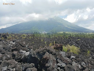
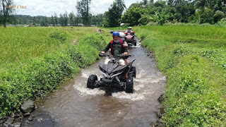
Mount Mayon, is an active stratovolcano in the province of Albay in Bicol Region. It is renowned as  "perfect cone" because of its symmetric conical shape and was declared as a national park on July 20 of 1938, together with the surrounding landscape. It was then reclassified as a Natural Park and renamed as the "Mayon Volcano Natural Park" in 2000. According to local folklore, the volcano refers to the legendary princess-heroine Daragang Magayon which means as "Beautiful Lady".

As of this writing, the famous volcano is still closed and prohibited from any hiking activities as amended by the local government and Philvocs. Several ATV tours were organized to provide the safest and legal way to enjoy it's beauty, so that tourists can still experience the thrill of what Mayon has to offer. It features riding on an all-terrain vehicle, driving through lahar field, streams, passing lava walls, rocks and even grassland with Mt. Mayon on the background for a post card-like setting.

Let us all be a responsible mountaineer and law abiding citizen. Please refrain from participating and organizing "backdoor hikes" aka as illegal hikes.

Pinoy Solo Hiker - Mayon ATV Tour

Pinoy Solo Hiker - Mayon ATV Tour

Pinoy Solo Hiker - Mayon ATV Tour

Pinoy Solo Hiker - Mayon ATV Tour

Pinoy Solo Hiker - Mayon ATV Tour

Pinoy Solo Hiker - Mayon ATV Tour

***The following images were shared to me by my sister who went on a Mayon ATV Tour.

Monday, September 25, 2017

Bridal Veil Falls

Located in Twin Peaks, Tuba Benguet and one of the four waterfalls that are situated along the Kenon Road. It was named as such because the cascade resembles a "bridal veil" that drops to more than a 120 ft. into a deep catch-basin surrounded by craggy boulders and rocks making it ideal for swimming and even diving. 

In order to reach the falls, one will have to cross a 70 meter hanging bridge across the Bued River below. It is just a minute walk from the highway, making Bridal Veil Falls one of the most accessible waterfalls in Kenon Rd. and definitely a must visit places for anyone who visits Baguio City.

Pinoy Solo Hiker - Bridal Veil Falls

Pinoy Solo Hiker - Bridal Veil Falls

Pinoy Solo Hiker - Bridal Veil Falls

Pinoy Solo HIker - Bridal Veil Falls

Pinoy Solo Hiker - Bridal Veil Falls

Pinoy Solo Hiker - Bridal Veil Falls

How to Get There:
It is visible along the Kenon Rd. in Tuba, Benguet

Tuesday, September 19, 2017

How to Avoid Leg Cramps During Hiking

Pinoy Solo Hiker - How to Avoid Cramps During Hiking

Hiking has become one of the most popular activities among Filipinos in recent years, thanks to Facebook and other social media platforms that opened the doors to outdoor enthusiasts.

It generally involves a long and steady aerobic workout with fitness benefits that rivals other more intense, higher impact activities. Although it is a non-competitive recreational activity, the constant climbing and descending can lead to cramping and injury. According to Men's Fitness Magazine, besides the overuse of the muscles, leg cramping is also caused by dehydration, electrolyte imbalance from sweating, and insufficient carbohydrate intake.

During hiking, the muscles in the leg contract while in motion and stretch out when motion is completed. The leg muscles stabilize you while you climb and descend on rugged terrain which involves both concentric muscle contraction and eccentric muscle contraction. Concentric muscle contraction is used for hiking uphill, cycling, and lifting weights while eccentric action is used for reducing speed when descending downhill.

Here are the common causes of leg cramps during hiking.

Lack of eccentric muscle training
According to Gale Bernhardt, USA Triathlon coach, most leg cramps, soreness, and injury are from eccentric contraction. The eccentric muscle contraction usually happens during descent which is used to slow (or stop) the momentum, the knee and hip muscles must contract eccentrically to reduce the impact on your weight-bearing lower body. Most of the daily activity, including strength training, does not involve enough eccentric motion. The best way to train these muscles is by walking downhill or downstairs. Squats are another exercise that you can do to build eccentric muscle strength and reduce cramping and soreness.

Dehydration
Dehydration is another common reason for leg cramping while hiking. Adequate fluid intake is important because it is needed to process nutrients in the body which ultimately provides you with energy. Maintaining proper hydration prevents dramatic shifts of fluid in your cells, which contributes to abnormal muscle contractions and muscle cramping. Therefore, if you experience cramping while you are hiking, the first thing you should do is to drink water.

Electrolyte Imbalance 
Aside from losing water during sweating, you also lose electrolytes, especially sodium and chloride (salt). If drinking water does not reduce cramping while backpacking, salt depletion could also be the culprit. Muscles sometimes becomes swollen when salt is depleted which causes intense pain. Thus, eating a salty snack and drinking water as soon as you feel cramping is the fastest way to get sodium into your body or by adding a pinch of salt to your drinking water might do. If you are sodium deficient, the cramps will subside within minutes.

Another cause of cramps is through the imbalance of electrolytes: potassium, calcium, and magnesium, which are all essential for muscle function. During hikes, I personally bring a bottle of Powerade or Gatorade to replenish the electrolytes I've loss through sweat and at the same time prevent dehydration. Electrolytes are essential for retaining water in the body. If you are deficient in any of these minerals, you may remain dehydrated and still at risk for cramps, no matter how much water you drink.

Inadequate Carbohydrate Consumption
Carbohydrates are the preferred source of energy used by the body which are the most efficient fuel source for the muscles. Hiking and other endurance activities require a higher daily intake of carbs to keep up with energy demands. Not eating enough carbohydrates can deplete stores of glycogen causing impaired muscle functioning, which might lead to muscle cramps.

So, before you hit the trail, start by strengthening the quadriceps with eccentric exercise. When on the trail, make sure you keep a proper diet and drink plenty of water. Give also yourself multiple rest stops on the days when you are climbing and descending more than you are used to, I usually hike at least once a month. Here are the essentials that I bring during a hike: adequate supply of water (I usually share my spare water to colleagues), Powerade/Gatorade or Hydrate, Trail Food (I prefer burger which both contains carbs and protein and of course chocolates) and Salty foods.


Reference: https://health.clevelandclinic.org/dont-let-foot-cramps-charley-horses-slow/

Monday, September 18, 2017

The MalacaƱang of the North

Known to the locals as "MalacaƱang ti Amianan", the MalacaƱang of the North is a 5-hectare property situated in Paoay, Ilocos Norte overlooking the beautiful Paoay Lake as it's backdraft. It was once the official residence/rest house of the late President Ferdinand Marcos and his family whenever they are in Ilocos.

It is a 2-storey, intricately designed mansion that resembles a 19th century "Bahay na Bato" with a mix of Spanish and Ilocano architecture given by first lady Imelda Marcos to former Pres. Ferdinand Marcos as a gift for his 60th birthday.  

Today, it serves as a presidential museum with each room having a theme of historical events from the Marcos era: Study, Agriculture, Diplomacy, OFW (overseas Filipino workers), Culture, Nation Building and Family.

Pinoy Solo Hiker - MalacaƱang of the North

Pinoy Solo Hiker - MalacaƱang of the North

Pinoy Solo Hiker - MalacaƱang of the North

Pinoy Solo Hiker - MalacaƱang of the North

Pinoy Solo Hiker - MalacaƱang of the North

Pinoy Solo Hiker - MalacaƱang of the North

How to Get There:
1. Ride a bus bound for Laoag (Farinas, Florida and Partas)
2. Once in Laoag, you can flagged/hire trikes to your destination.

Friday, September 15, 2017

Bangui Windmills

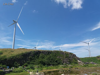
Located at the municipality of Bangui in Ilocos Norte,  the windmills are strategically placed facing the West Philippine Sea from where the wind blows towards the land. According to Northwind Bangui Bay Project which operates the windmills, the location along the shore is optimal in removing windbreaks. The site is free from any trees and vegetation which stretches approximately 9 km. along the shoreline and are 236 meters apart which are lined up giving a composition to the scene. 

The area is still undeveloped and uninhabited making it an ideal site for the turbines. However, some locals have built stores that sells souvenir items (miniature windmill) in the area to cater to the large influx of tourists who visits the place. By the way, the windmills of Bangui is much bigger and larger compared to those that are located in Pililia.

Pinoy Solo Hiker - Bangui Windmill

Pinoy Solo Hiker - Bangui Windmill

Pinoy Solo Hiker - Bangui Windmill

Pinoy Solo Hiker - Bangui Windmill

Pinoy Solo Hiker - Bangui Windmill

How to Get There:
1.) From Laoag City, ride a jeep bound towards the town of Burgos. 
2.) The windmill blades are visible from the highway while you are traveling. 

Wednesday, September 13, 2017

Mt. Tagapo

Situated in Talim Island, the largest inland island in Luzon that is located in Laguna Lake which is the largest lake in South East Asia. Mt. Tagapo is the highest peak in Talim Island, the journey includes an hour of boat ride from Brgy. Janosa in Binangonan, Rizal to the island of Talim. It was known to locals as "Mt. Susong Dalaga" and was mentioned by Jose Rizal in his diary "Aboard the Salvadora: Calamba to Barcelona" dated May 8, 1882 (Monday) referring to "Mt Susong Dalaga of Talim Island" because the slopes resembles a maiden's breast.

It may not be as high compared to other mountains which stands at only 1437 ft. above sea level but it rewards the climbers with a spectacular view of the Laguna Bay and the surrounding fishing villages making it a great viewing area for both sunrise and sunset. 

The trail that leads to the summit is predominantly composed of bamboo which most of the locals on the island used to make furniture, toothpicks, and charcoals to earn for their living. Thus, the name Mt. Tagapo originated from the word “Taga” which means “to chop” which refers to the activities of chopping bamboos that are found throughout the area. The last part of the trail is composed of open grassland slope that resembles the background picture of "Windows XP" which is more or less 200 ft. that has some steep portion but still manageable even for beginners. 

Pinoy Solo Hiker - Mt Tagapo

Pinoy Solo Hiker - Mt Tagapo

Pinoy Solo Hiker - Mt Tagapo

Pinoy Solo Hiker - Mt Tagapo

Pinoy Solo Hiker - Mt Tagapo
Photo credit: Michael Angelo

Pinoy Solo Hiker - Mt Tagapo

Pinoy Solo Hiker - Mt Tagapo

Pinoy Solo Hiker - Mt Tagapo

How to Get There:
1. From EDSA Crossing, ride a jeep or van bound to Binangonan (tell the driver to drop you off near the ferry port).
2. Ride a trike bound to the port
3. Once in Binangonan Port, ride a ferry bound to Brgy. Janosa

Sunday, September 10, 2017

Cagsawa Ruins

The church of Cagsawa was originally built in 1587 during the Hispanic occupation of the Philippines. It was burned down by Dutch pirates in 1636 and was rebuilt in 1724 by the Franciscan friars but was destroyed again during the eruption of Mayon Volcano along with the town of Cagsawa in February 1, 1814.

The ruins are  part of the Cagsawa Park which is maintained by the municipal government of Daraga and the National Museum of the Philippines that is one of the most popular tourist destinations in the area. It was even recognized by the International Tourism Bourse (ITB) which is one of the world’s top travel trade shows based in Berlin, as one of the places to visit in Asia.

The belfry has an approximate distance of 11 km. away from the volcano which gives a picturesque background setting for tourists.

Pinoy Solo Hiker - Cagsawa Ruins

Pinoy Solo Hiker - Cagsawa Ruins

Pinoy Solo Hiker - Cagsawa Ruins

Pinoy Solo Hiker - Cagsawa Ruins

How to Get There:
1. Ride a bus bound to Legazpi City (Philtranco, Superlines, DLTB & Cagsawa).
2. Take a jeepney going to Guinobatan/Ligao City/Oas/Polangui. Tell the driver to drop you off to Cagsawa Ruins. From the highway, it's a 500 meter walk.

Thursday, September 7, 2017

Kapurpurawan Rock Formation

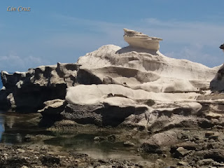
Situated in the coastline of Burgos beside Bangui Bay in Ilocos Norte, Kapurpurawan Rock is one of the must visit places and pride jewel of the Ilocos Region. 

The word "Kapurpurawan" originated from the Ilocano word "Puraw" that literally means "white". True enough, it is composed of stunning rock formations, which according to geologist was formed through a number of geological periods known as sedimentation. It resembles "Animasola Rock Formation" of Burias and Tinipak River of Daraitan", both having the same geological features of white and marble-like rock formations.

Several years ago, visitors had to trek on rocks, marshes and even walk on mud just to get to the rock formations. But now, the local government have built footpaths, bridges, and stairs to make it easier for the tourists to visit the place. Climbing the rocks are prohibited because some portions are fragile.

Pinoy Solo Hiker - Kapurpurawan Rock Formation

Pinoy Solo Hiker - Kapurpurawan Rock Formation

Pinoy Solo Hiker - Kapurpurawan Rock Formation

Pinoy Solo Hiker - Kapurpurawan Rock Formation

Pinoy Solo Hiker - Kapurpurawan Rock Formation

How to Get There:

1.) Ride a bus bound to Laoag via Farinas, Florida and Partas.
2.) Once in Laoag, ride a bus/van bound to Burgos or Pagudpod then tell the driver to drop you off at the access road to Kapurpurawan near Burgos Poblacion (you can also hire trikes to get you there, just haggle).

***The following pictures was shared to me by sister who went to Ilocos Norte, thus it was based on her pictures and narration that this write-up was made.

Sunday, September 3, 2017

SBMA Beach

Subic Bay is located in Olongapo City that is situated in the province of Zambales. It was developed by the United States Naval base which was once the largest U.S. military naval base in Asia. It became the base of the United States 7th Fleet until 1991 when the Philippine Senate rejected terms for renewal of the lease of the base. During Mt. Pinatubo's eruption of the same year, volcanic ashes covered the Naval Base, destroying a significant number of structures. 

It is a public beach that is located in Subic Bay, in front of Waterfront Rd., thus it is known to some passerby as "Waterfront Beach", however the real "Waterfront Beach" is located in Morong, Bataan. Since it is a public beach it is free of any entrance fee, however swimming is widely prohibited. But then again, one can still relax and enjoy the calming waves of the sea. Let alone, walk on the grayish fine grain sand and stroll around the beachfront while watching the sun as it envelopes the bay with the mountain ranges of Zambales giving a paradise like setting.

Pinoy Solo Hiker - SBMA Beach

Pinoy Solo Hiker - SBMA Beach

Pinoy Solo Hiker - SBMA Beach

Pinoy Solo Hiker - SBMA Beach

Pinoy Solo Hiker - SBMA Beach


Pinoy Solo Hiker - SBMA Beach


How to Get There:
1. From Cubao, you ride buses bound to Olongapo.
2. Once in Olongapo you can walk to Waterfront Rd., to which the SBMA Beach is locaed.