Situated between the provinces of Ifugao and Mountain Province, Mt. Amuyao is the 11th highest mountain in the Philippines which stands at 8865ft above sea level. It is also known as Mt. Finaroy where it was discovered by two prominent hunters named Amfusnun and Limipaw which serves as a hunting ground of Barlig ancestors and the people have claimed their ancestral right over the whole mountain.
According to a
local legend which tells about the first Ifugao couple, Bugan and Wigan who took refuge in this mountain during the 40-day deluge that inundated the province. Being the only survivors, they became the first ancestors of the Ifugaos.
We did a reverse traverse from Batad (Ifugao) and eventually exits in Barlig (Mt. Province), this is arguably a more insanely trail which is reversing the usual traverse trail, coined as the Mount Amuyao Reverse Traverse trail The difficulty of this may increase from 8/9 to 9/9 with the same trail class of 1-3.
From Batad Saddle Point we started the trek which passes the world-renowned
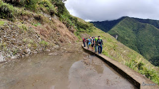
Batad Amphitheater Rice Terraces, it is considered the easiest part of the trek with gradual ascent passing several paddies and gradual stair climb along the trail. Then after several hours, we arrived at Barangay Cambulo where we took our lunch. It was starting to rain when we started the trek towards Sitio Pat-yay which is characterized by a narrow path of the rice terraces or ‘pilapil’ which could be more challenging and quite dangerous to deal with, most especially during a heavy downpour. It requires an almost 1200 ft ascent through a steep and muddy trail, which will then descend a 1020ft along an equally steep forested trail which becomes muddy and slippery when rain sets in. I had my share of mishap during the descent to Pat-Yay where I slipped through a ravine. Fortunately, I was able to cling on to some rocks and roots, it was one of those moments when my whole life flashed back. Earlier that afternoon, I almost stepped on a snake as it was one of those days that I'm thankful that I am still alive which makes it truly unforgettable. At around 1900h we reached Pat-yay Village where we had our dinner and camped for the night. Our guide told us that is almost equidistant between Barangay Cambulo and the summit of Mount Amuyao.
The next day we resumed the trek which is considered by some as the most difficult part of the reversed traverse trail because it was pure assault. Based from my Casio Altimeter there is a total of 4980ft altitude gain from Pat-Yay to Mt. Amuyao summit which only means pure assault where the ascending part is characterized by steep yet forested trail and mossy forest which is infested with blood-sucking limatiks. After several hours of trekking, we reached the waiting shed which is considered the halfway mark to the summit, there is also a nearby watersource where one can refill. The trail towards the summit is mostly mossy forest then it becomes an open grassland which then passes a ridge consisting of a steep assault that is about 15-20 minutes trek before reaching the summit of Mount Amuyao.
The summit is characterized by a bunker within the compound GMA and ABS-CBN Network towers where hikers coming from Barlig can spend the night (it is actually part of Barlig so they have the access key). According to Kuya Jun (our guide) each part of the towers/bunkers were carried from Barlig all the way to the summit manually at 20pesos per kilo. Since we don't have a key to the bunker we pitched our tents outside, have some dinner and of course spend the night on socials. It was freaking cold and based from my Casio thermometer it was ranging between 8 to 12 degrees, honestly, I wasn't able to sleep until 3am.
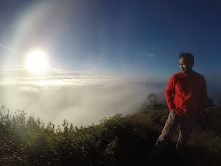
The next day everyone was in awed as we witnessed the sea of clouds, some say that Mt Amuyao has more chances of viewing the sea of clouds compared to that of Mt. Pulag. It offers a 360-degree view of the surrounding landscape which includes Benguet (W), Abra (WNW), Kalinga (N), Cagayan (NE), Isabela (E), and Ifugao (S) and of course the breathtaking view of sunset and sunrise. We took some pictures and cherished the moments, then had our breakfast (courtesy of Ken and Skyy, thanks guys sa masarap na meal) and prepared for the final leg of the trail.
From the Summit of Mount Amuyao to Sitio Macalana, Barangay Barlig, Mountain Province – Rodel, Edam and I descended it in almost 2 hours which is more or less 7 km. The trail is characterized by a very steep and narrow but established pathway consists of wooden steps and stairs that can be very dangerous and slippery when wet. The last part of the trail after passing thru the rice terraces, hikers still have to deal with several concrete stairways up to the end point at Sitio Macalana, Barlig then we headed directly to the Police Station to register which commenced the end of the trek that is approximately 32 to 34km and had a total altitude loss of 3960 ft from the summit to Barlig.
 |
| Photo credits to Skyy Chiong |
 |
| Kuya Jun, Edam, Emer, Marissa, Ramon, Ken, Rodel, Mojo and Ken (photo credit) |
 |
| Photo credits to Edam Bunso |
 |
| (photo credit: Ramon Obmerga) |
Mossy Forest
 |
| Rodel, Sky, Mojo, Marissa, Edam, Emer, Ramon, Kuya Jhun and Ken (photo credits) |
 |
| Photo Credits to Mojo Santiago |
 |
| Photo credits to Mojo Santiago |
 |
| Photo Credits to Marissa Binuhe |
Barlig
 |
| Kuya Jun, Skyy, Emer, Mojo, Ramon, Rodel, Marissa, Edam and Ken (Photo credits) |
How to Get There:
1. Ride a bus bound for Banaue via Coda lines
2. Take a rented jeep to Batad (jump off point)
I joined a DIY KKB organized by Ken Lignes, highly recommend at astig pa magluto.
Together with the whole
Team Banayad sa Pilapil: Skyy, Mojo, Ramon, Marissa, Rodel, Edam and
Kuya Jhun our guide


