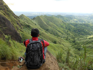
Located at the town of Nasugbu in Batangas lies the beautiful mountain ranges of Mt. Batulao which came from the word "Bato sa Ilaw" or illumined rocks and stands at an altitude of 2450 feet above sea level in the summit. The trail is comprised of rolling terrains between the mountain ridges in an open space of grassland and ravines.
There are three trails for Mt. Batulao: the Old Trail which is an open space composed of ridges and ravines; no trees but offers a picturesque view and of course, the New Trail is composed of woodlands and no ravine yet does not have a great scenery. We've decided to use the Old Trail because we want to enjoy the beautiful landscape of the said mountain, we didn't also have a guide and so we trekked at our own pace. Then there is also the less traveled Toong trail which is a bit challenging than the usual trail and what makes it recommendable is that it does not have syndicated and illegal toll fees from the locals.
In general, Mt. Batulao is a great mountain for beginners because of the breathtaking views that it offers and the beginner-friendly trails that can be easily negotiated. But then again, since there are no trees to cover from the scorching heat of the sun, it becomes a challenge most especially to those who are relatively new to hiking. Along the trail, one will encounter 3 separate rope segments where one has to rappel 70 degrees upward slope.
In general, Mt. Batulao is a great mountain for beginners because of the breathtaking views that it offers and the beginner-friendly trails that can be easily negotiated. But then again, since there are no trees to cover from the scorching heat of the sun, it becomes a challenge most especially to those who are relatively new to hiking. Along the trail, one will encounter 3 separate rope segments where one has to rappel 70 degrees upward slope.
Then after 2-3 hours of trekking one will reach the summit which will reward anyone with a refreshing breeze and a 360 degrees view of the surrounding landscape that includes: Tagaytay City, Nasugbu beach, Talisay, South China Sea, Taal Lake, and even Mt Maculot can be seen from afar as well as the neighboring Mt Talamitan.
How to Get There:
1.) Take a bus bound to Nasugbu (DLTB or Jac Liner), they have terminals in Cubao and LRT Buendia
2.) Tell the conductor to drop you off in Ever Crest Golf Course.
3.) Once in Ever Crest. You can then ride a trike to the jump-off point (the Pinoy Solo Hiker together with his friends opted to walk approx. 30 mins)
***The locals along the trails of Mt Batulao are notorious for their illegal toll fees making all throughout the trail and I do not condone such actions. I would recommend Batulao via Toong trail instead.
***The locals along the trails of Mt Batulao are notorious for their illegal toll fees making all throughout the trail and I do not condone such actions. I would recommend Batulao via Toong trail instead.


Local guide po mt batulao pm for info and latest update (09101317847)
ReplyDelete