Wednesday, January 25, 2017

Mt. Damas Traverse

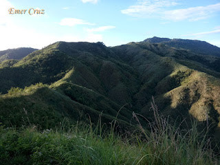
Located in the bordering towns of Mayantoc, Camiling and San Clemente in Tarlac province, Mt. Damas stands at only 2250 ft. above sea level.  Although it is not as high compared to other major mountains but the trail that leads to the summit offers a great challenge to some hikers due to its steepness which is comprised of full assault and cardiac trails on an open grassland ridge which has become a great challenge for some and maybe overrated to some extent.

Ironically, the jump-off point in Dueg resettlement area has almost the same elevation as Mt. Damas, thus making the traverse trail comprised of descending and ascending through a series of steep mountain ridges then one would pass several river crossing (trekking along the river),  for almost 2.5km until reaching the mountain base that would commence the assault with an average of 50-60 degrees slope before reaching Mt. Damas. Upon reaching the summit one will be rewarded with a 360 degree view of Tarlac and Pangasinan making it one of the most scenic and rewarding mountain in Tarlac not to mention scorching. There are no trees to cover under the heat of the sun except the lone tree that paved the way for Mt. Damas to be discovered by Game Nest mountaineers through their exploration.

Pinoy Solo Hiker - Mt. Damas

Pinoy Solo Hiker - Mt. Damas

Pinoy Solo Hiker - Mt. Damas

Pinoy Solo Hiker - Mt. Damas

Pinoy Solo Hiker - Mt. Damas

Pinoy Solo Hiker - Mt. Damas

Pinoy Solo Hiker - Mt. Damas

How to Get There:

1. Ride a bus with a sign board that passes Camiling (Solid North: San Carlos).
2. Once in Camiling, ride a tricyle bound to Sitio Dueg.
3. Secure a guide
*** I joined an event organized by Adventurous People

Sunday, January 22, 2017

Silverio's Seafood Resto

My wife and I celebrated our 2nd wedding anniversary and we thought of something unique that has the classic taste of Dagupan yet at an affordable price. So, we've decided to celebrate it in Silverio's Seafood Resto which according to the locals, vie with Matutina's as the best Seafood resto in town.

We were the first customer to arrived so we had the luxury to explore, take some pictures and find the best seat in place. It has two sections; the main resto in which the center stage where the live bands performs and the other part is the "riverside" in which tables are lined up overlooking Dawel River. 

The house specialties are usually "Bangus" dishes (Dagupan is the "Bangus" capital of the Philippines aka "Milkfish", no wonder it's their specialty). We ordered Relyenong Bangus, Shrimp Tempura, Crab Soup w/ Quail Eggs and we also had Blueberry Cheesecake for dessert. In my opinion, the food was just average tasting, but it was good enough to fit my budget and it was served fast by courteous staff. What I mostly like is the ambiance and the cool breeze that comes from the river.


Rating:
7 out of 10

Tuesday, January 17, 2017

Nid's Balot n Bilao

One of the most affordable food restaurant that serves native Filipino dishes that is usually wrapped or served in banana leaves, thus the name "Balot" comes from.

There are many food choices at Nid’s Balot among which are the "Silog" varieties (Fried Rice & Egg), Bulalo and of course the classic Filipino Adobo (chicken or pork marinated in soy sauce and vinegar) and  comes with atsara (Papaya pickle).

I was really hungry and need to have my dinner before going home to the province - So I ordered Lomi, Breaded Pork, Pork Adobo and Halo-Halo; I was truly satisfied both in taste, price and service which is worth for my money's value.


They also have a wide array of Filipino desserts and drinks among which are Ube Halaya, Leche Plan and Halo-Halo to name a few. And they also accept made to order "Pancit" which is placed in a Bilao.

Several stores are located across the Metro and also in Calamba City all of which are open 24/7.

Pinoy Solo HIker - Nid's Balot n Bilao

Pinoy Solo HIker - Nid's Balot n Bilao

Pinoy Solo HIker - Nid's Balot n Bilao

Pinoy Solo HIker - Nid's Balot n Bilao


Pinoy Solo HIker - Nid's Balot n Bilao

Pinoy Solo HIker - Nid's Balot n Bilao

Rating:
8 out of 10

Sunday, January 15, 2017

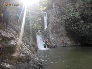
Ubod and Si-El Falls (Damas)

Situated in the mountain ranges near the foot of Mt. Damas in San Clemente and Camiling in Tarlac. Two waterfalls have gain popularity among the mountaineering community known as Si-El Falls and the much grander Ubod Falls.

In order to reach the two falls, one has to trek through a forested trail and climb a very steep mountain ridge with almost 70 degrees assault trail of almost 400 ft., then descend again through the river which will then require river crossing for almost 30 minutes. In the final stages of the trail, one has to climb and maneuver through rocks to reach first falls known as Si-El Falls that was named after the school of the first explorer who discovered it. Then another another 10 minutes of trekking through rocks one will reach the much grander Ubod Falls (I'm not familiar with it's name etymology) which has an estimated 120 feet drop of water that cascades to a large catch basin.

We were fortunate that it was not raining during our trek, precaution must be observed during rainy days as rocks becomes too slippery and flash floods do occur.


Ubod Falls
Pinoy Solo HIker - Ubod Falls

Pinoy Solo HIker - Ubod Falls

Si-El Falls
Pinoy Solo HIker - Ubod Falls

Pinoy Solo HIker - Si-El Falls

River Crossing
Pinoy Solo HIker - Ubod Falls

Pinoy Solo HIker - Ubod Falls

Pinoy Solo HIker - Ubod Falls

How to Get There:

1. Ride a bus with a sign board that passes Camiling (Solid North: San Carlos).
2. Once in Camiling, ride a tricyle bound to Sitio Dueg.
3. Secure a guide
*** I joined an event organized by Adventurous People

Sunday, January 8, 2017

Mt. Tapulao (High Peak)

The highest peak in Central Luzon which is located in the province of Zambales, Mt. Tapulao is also known as High Peak. It has an altitude of 6685 feet above sea level and is considered to have one of the highest altitude gain  which is equivalent to 6000 ft. from the jump off point to the summit.

According to the locals, it's name was derived from Sumatran Pine Trees which means "Tapulao" in the local dialect. The mountain was once a site of a large-scale chromite mining operations and the destruction is still evident in the mine pits and other related structures along the trails. 

The trail that leads to the summit from the jump off point has a total distance of 18 km. by trekking the mining road composed of rocks and large boulders on a ridge which is situated on the side of the mountain. Pine trees becomes a common sight of the trail upon reaching the 12 km. stretch of the trek all throughout the second campsite (Kilometer 16) which has the familiar cool breeze and temperature that resembles Benguet province. Upon arriving at the second campsite one will have to go through the "mossy forest" (resembles that of Mt. Dulang- Dulang and Mt. Pulag) and has to trek another 2 km., thus reaching the summit which marks the total 18 km. distance of the trail. The summit offers a 360-degree view of Zambales mountain ranges, Ligayen gulf, West Philippine Sea and the town of Zambales.

The Summit
Pinoy Solo Hiker - Mt. Tapulao

Pinoy Solo Hiker - Mt. Tapulao

Pinoy Solo Hiker - Mt. Tapulao

Mossy Forest
Pinoy Solo Hiker - Mt. Tapulao Mossy Forest

Pinoy Solo Hiker - Mt. Tapulao Mossy Forest

Pinoy Solo Hiker - Mt. Tapulao Mossy Forest

The Pine Forest
Pinoy Solo Hiker - Mt. Tapulao

Pinoy Solo Hiker - Mt. Tapulao

Pinoy Solo Hiker - Mt. Tapulao


Pinoy Solo Hiker - Mt. Tapulao

Pinoy Solo Hiker - Mt. Tapulao

The Trail
Pinoy Solo Hiker - Mt. Tapulao

Pinoy Solo Hiker - Mt. Tapulao

Pinoy Solo Hiker - Mt. Tapulao

Pinoy Solo Hiker - Mt. Tapulao

Pinoy Solo Hiker - Mt. Tapulao

Pinoy Solo Hiker - Mt. Tapulao


Vlog Version


**   I joined an event organized by Diwata RR Tours
*** I recommend Kuya Ronnie Pacawin (09124171914) as a guide in Mt. Tapulao

Tuesday, January 3, 2017

Mt. Maynoba

Possibly the mountain with the highest success rate of viewing the sea of clouds in the mountain ranges of Rizal province. Mt. Maynoba stands at an altitude of almost 2400 ft. above sea level opened last early 2016 and is part of the Maynoba Circuit that includes Mt. Cayabu and the descent traverse to the eight waterfalls. 

The trail that leads to the summit resembles Mt. Maculot which has several steep and rocky portions and is composed of open grassland and ridges, it has a total of 1400 feet elevation gain from the jump off point. Upon reaching the summit, one will be rewarded with a 360 degree view of the Sierra Madre mountain ranges and peaks from Tanay, Mt. Irid from Gen. Nakar and Infanta, Quezon can also be seen from afar. 

With strong gush of winds during our hike, we were not fortunate to witness the famed "sea of clouds" but then again the other highlight of our climb was the descent traverse to the 8 waterfalls.

Pinoy Solo Hiker - Mt. Maynuba

Pinoy Solo Hiker - Mt. Maynuba

Pinoy Solo Hiker - Mt. Maynuba

Pinoy Solo Hiker - Mt. Maynuba

Pinoy Solo Hiker - Mt. Maynuba

Pinoy Solo Hiker - Mt. Maynuba

Pinoy Solo Hiker - Mt. Maynuba

Pinoy Solo Hiker - Mt. Maynuba

** I joined an event organized by Traveling Adventure