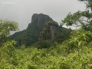
Located in Maragondon but the jump-off point of Mt. Marami starts in Ramirez, Magallanes, Cavite. "Marami" in the Tagalog language means numerous, thus the name perfectly describes the mountain's attributes. The trail is composed of a series of forks and labyrinth, thus the name can also mean as 'Maraming Ligaw" which passes through a forested yet muddy trail that could also mean as "Maraming Putik". The initial part of the trail starts a 500 ft descend from the jump-off point until reaching the first river crossing and even crossing a makeshift bamboo bridge. From there on the trail has a gradual ascent until the final 600ft assault to reach the summit which has an elevation of 1325ft. The whole trail has a total length of 19.6km through the backtrail which I personally describe as "Maraming Lakarin" for a minor hike.
Just like the neighboring Pico de Loro, Mt Marami is also composed of enormous rock formations and massive composite of pillars and towers which is way challenging than the latter. Thus, this was primarily the reason why Mt Marami got it's named, "Maraming Bato" because the mountain is composed mainly of numerous and gigantic rocks. The trail will let the hiker to experience the “Silyang Bato” which is composed of composite rock pillars on the summit where it offers a refreshing strong gush of winds and picturesque 360° view of Cavite.


No comments:
Post a Comment