Friday, September 21, 2018

Mt Samat (Shrine of Valor)


Bataan will always have a special place in the pages of Philippine History and it was considered as the first line of defense against the invading Japanese forces. A tribute was made to honor the heroism and gallantry of soldiers which can be found in Mt. Samat where the Shrine of Valor (Dambana ng Kagitingan) was erected to commemorate the Battle of Bataan. Also stood is a 302ft  (92m) memorial cross which also serves as a viewing deck.

Mt. Samat is located in the town of Pilar in Bataan with a distance of 135kms from Manila. It has an elevation of 1600ft above sea level and a total elevation gain of 1470ft from Linao National Rd. (Diwa intersection). Although Mt Samat is much smaller than the neighboring mountains, Mt Mariveles and Mt Natib but it's historical significance cannot be discounted. One can easily reach its summit by walking through a cemented road or any means of transportation. I opted to walk the 7kms stretch for about 75mins, all for the love of hiking and sightseeing.

"If you want to understand today, you have to search yesterday". ~Pearl Buck

Pinoy Solo Hiker - Mt Samat
As viewed from the viewing deck of the memorial cross

Pinoy Solo Hiker - Mt Samat

Pinoy Solo Hiker - Mt Samat

Pinoy Solo Hiker - Mt Samat
Inside the memorial cross' viewing deck

Pinoy Solo Hiker - Mt Samat

Pinoy Solo Hiker - Mt Samat

Pinoy Solo Hiker - Mt Samat
Mt Mariveles

Pinoy Solo Hiker - Mt Samat

How to Get There:

1.) Take a bus bound to Balanga, Bataan (Genesis or Bataan Transit), they have terminals in Cubao and Pasay City
2.) Once you are in Balanga Terminal, you can ride a jeep bound to Cabog Cabog (tell the driver to drop you off in the Diwa Intersection
3.) You can then ride a Trike to the Hero Shrine or walk

Friday, September 14, 2018

Backpacking in Cambodia (Siem Reap)

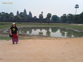
My sister who went on a tri-country trip to Cambodia-Thailand and Vietnam shares her experience about her visit to the three South East Asian country, thus it was based on her pictures and narration that this article was written. Out of the many pictures that she had, she only shared most of her pictures particularly in the city of Siem Reap, Angkor Wat and Ta Prohm.  

Cambodia is located in the southern portion of the Indochina peninsula in Southeast Asia bordered by Thailand to the northwest, Laos to the northeast, Vietnam to the east and the Gulf of Thailand to the southwest. The official English name of the country is "Kingdom of Cambodia". Kampuchea is the shortened alternative to the country's official name in Khmer which was derived from the Sanskrit name kambojadeśa. The name "Cambodia" is used most often in the Western world while "Kampuchea" is more widely used in the East. The capital is Phnom Penh which is also the most populous city in Cambodia and is more than 300km away from the city of Siem Reap which is the most popular tourist destination in the said country and can be reached by 6hours travel via mini buses. 

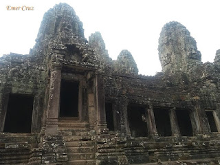
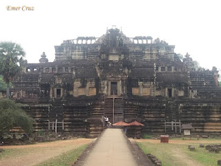
Siem Reap's main attraction is the Angkor Wat which literally means "city of temples" that is composed of a numerous temple complex and is considered as the largest religious monument in the world. The name "Siem Reap" means "Defeat of Siam" and is commonly taken as a reference to an incident in the centuries-old conflict between the Siamese and Khmer kingdoms. 

Angkor Wat was originally constructed as a Hindu temple dedicated to Vishnu for the Khmer Empire and was gradually transformed into a Buddhist temple towards the end of the 12th century. Archeologists consider it as the best-preserved temple at the site, it is the only one that has remained a significant religious center since its foundation. The temple is admired for the grandeur of the architecture and for the numerous devatas which adorn its walls. In fact, Angkor Wat has become one of the most recognizable symbols for  Cambodia.

Night Market in Angkor is also a must try when in Cambodia. My sister was able to buy several souvenirs which usually starts every evening. This is a popular place to buy a bargain and is comparable to a local Tiangge or Divisoria which is filled with stalls, handicrafts, Class-A North Pace bags at very low prices and of course all sorts of Cambodian souvenirs.

Pinoy Solo Hiker - Cambodia

Pinoy Solo Hiker - Cambodia

Pinoy Solo Hiker - Cambodia

Pinoy Solo Hiker - Cambodia

Pinoy Solo Hiker - Cambodia

Pinoy Solo Hiker - Cambodia

Pinoy Solo Hiker - Cambodia

Pinoy Solo Hiker - Cambodia

Pinoy Solo Hiker - Cambodia
The Royal Palace @ Phnom Penh

Pinoy Solo Hiker - Cambodia

Pinoy Solo Hiker - Cambodia

Pinoy Solo Hiker - Cambodia

Here are the following tours that you can take while visiting Siem Reap.

Angkor Tour:
Angkor Wat, Phom Bakheng, Baphuon, Bayon, Elephant Terrace, Phimeanakas

Big Circuit Tour:
Neak Pean, Banteay Samre, East Mebon, Ta Som, Preah Khan

Small Circuit Tour:
Ta Keo, Prasat Kravan, Bantay Kdei, Srah Srang, Ta Phrom

Tonle Sap Lake:
Kompong Phluk Floating Village, Flooded Forest, Tonle Sap Lake


-------------------------------------------------------------------------------------------------------------------------

Reference:
Chandler, David P. (1992) History of Cambodia.
Zhou Daguan (2007). A Record of Cambodia. Translated by Peter Harris. University of Washington Press.

***My sister and her friends bought a promo tri-city tour 

Saturday, September 8, 2018

Taal Lake (San Nicolas)

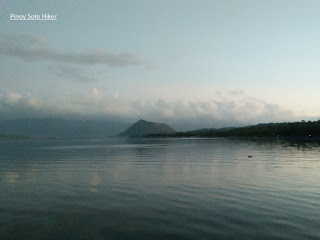
Last February 2018, I visited Taal Volcano via Tabaro trail and the main jump-off point is via a boat ride from the town of San Nicolas, Batangas which is one of the towns that surrounds Taal Lake. I was quite impressed with the baywalk that the local government has built making it worthy for this article.

Just a brief background, Taal Lake is located in the province of Batangas which is the country's third largest lake after Laguna de Bay and Lake Lanao. It was formerly known as Bombón Lake that surrounds the Taal Caldera which is a volcanic caldera and was declared as a national park by Proclamation No. 235 on July 22, 1967.

According to Philvocs, Taal Lake was once an inlet of the nearby Balayan Bay, and can be accessed through it. But when Taal Volcano erupted during 1754 which was also the volcano's largest eruption, it blocked the Pansipit River with tephra that blocked the lake's sole outlet to the sea. This caused the waters to rise which eventually submerged the several lakeside towns. According to the locals, some remnants are still visible underwater to this day.

I'll write my blog post for Taal Volcano via Tabaro trail in the following months. (I have so many pending posts).

Pinoy Solo Hiker - Taal Lake

Pinoy Solo Hiker - Taal Lake

Pinoy Solo Hiker - Taal Lake

Pinoy Solo Hiker - Taal Lake

Pinoy Solo Hiker - Taal Lake

References: 

  1. "Taal flyer - Chronology of Historical Eruptions of Taal Volcano". PHIVOLCS. 
  2. Sawyer, Frederic H. (1900-01-01). The Inhabitants of the Philippines. Library of Alexandria.
  3. Crossley, Professor John Newsome (2013-07-28). Hernando de los Ríos Coronel and the Spanish Philippines in the Golden Age. Ashgate Publishing, Ltd.
***I joined an event organized by John Sarco.

Monday, September 3, 2018

Maranat Falls

Maranat falls is part of Mt. Oriod which is located Norzagaray, Bulacan. It is usually hiked together with Mt Balagbag like we did as part of our year-end hike. It is important to know that it is required to get a permit from DENR Bulacan before you plan of going to Maranat Falls since this is a part of Ipo Watershed.

From Mt. Balagbag towards Maranat Falls, one will pass a establish grassland then descend a very slippery and forested trail for a total of 1500ft descend. From there on the trails which leads to Maranat Falls requires several river crossing that passes huge boulders for a total of 3.5km.

The last portion of the trail that leads to Maranat Falls requires some bouldering through slippery rocks and even fallen logs. The falls is characterized by a 3 tiered drop that feeds a catch basin with portions that are deep and we were discouraged by our guide not to swim near the cascade. The water is cold and crystal clear which offers a refreshing dip but not ideal for diving. 

Since Maranat Falls is a backtrail, we have ascended a total of 1500 ft that passes a forested trail and an open grassland on the way back to Mt. Balagbag.

Pinoy Solo Hiker - Maranat Falls

Pinoy Solo Hiker - Maranat Falls

Pinoy Solo Hiker - Maranat Falls

Pinoy Solo Hiker - Maranat Falls


Pinoy Solo Hiker - Maranat Falls

How to Get There:
1. From Cubao, ride a bus bound for Tungko (alight in Jollibee).
2. From Jollibee Tungko, ride a jeep bound for Licao-Licao
3. You can ride trikes towards Mt Balagbag or you can take a walk (we walk of course).
4. If you are interested to visit Maranat Falls you should first secure a permit from DENR Bulacan and it is also advisable that you get a guide since this is a part of Ipo Watershed which is part of Bulacan.


***DENR PENRO is located in McArthur Hi-way, Guinhawa, Malolos, Bulacan. 
Bring a letter of intent together with the names of the participants, or you may email it to denr_bulacan@yahoo.com

Contact numbers: 044-7947090, 044-6620434 & 044-7940152 


No Permit, No Climb. Wag Matigas ang Ulo...

It was Team Una's year-end DIY KKB hike