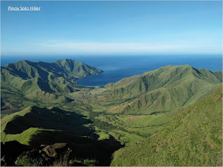
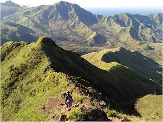
I've been to Mt. Balingkilat on three occasions, the first was the traverse to Nasasa Cove during the onset of Typhoon Marce way back last 2016. My second and third visit was both part of Cawag Hexa dayhike in 2018. My first ascent to the summit took 3h15m, and as I became more comfortable with the trail, I have also progressed the time to reach the summit with 3h5m on my second and 2h50m on my third time, all of which where I was part of the lead group.
Mt Balingkilat is one of the highest peaks in the Zambales coastal mountain ranges and coves area which stands at an altitude of 3600 ft. above sea level and it is also among my top ten favorites because of the scenic view that it offers. Back in the days, American naval servicemen who served in Subic Naval Base used to call it as the “Pointed Peak” but the indigenous people (Aetas) prefer to call it as Mt. Balingkilat which means "Mountain of Thunder" for the reason that most of the time the summit is engulfed in clouds with ravaging thunder storms.
The first part of the trail is composed of grassland (overgrown "Talahib" and "Cogon" grass are present throughout the trail). After an hour of trek one will reach the only tree in the midst of the grassland which marks the start of the assault. The assault trail is more or less 2500 feet in altitude gain which has a lesser grass and is predominantly a rocky portion. It becomes very steep in the final 600 feet before the summit where it requires technical climbing skills through rock walls and boulders with almost 90 degrees vertical climb for a total distance of 7.4km. from the jump off point to the summit and a total altitude gain of 3100ft to reach the summit.
The summit offers 360 degree picturesque view of Zambales mountain ranges: Mt. Cinco Pincos and coves: Anawangin, Talesayen, Nagsasa, and Silanguin Cove. Mountains in Bataan can also be seen from afar: Mt. Natib, Mt. Samat and Mt. Mariveles. And since most of the summit and majority of Balingkilat is a grassland, you can expect that is a blazing inferno and almost no trees to protect the hikers from the scorching heat of the sun. But compared to San Jose Circuit hike, Cawag mountains still has the soothing breeze from West Philippine Sea which makes it somehow cooler but still hellish.
Mt Balingkilat is usually hiked with a traverse to Nagsasa Cove or a traverse to the other mountains in the Zambales Coastal which includes Mt Nagsasa (Bira-Bira), Cinco Picos, Dayungan, Naulaw and Redondo for a complete Cawag Hexa. For both trails one has to descend a total of 1950ft through rocky ridges and steep knife edges before passing a portion of Mt Nagsasa.
 |
| Nagsasa Cove |
 |
| With Ate Lorna, Noemi, Manuel, Alano & Arvin |
 |
| With Akyat Tanaw Mountaineers: Jaime & Vincent |
 |
| Photo credits to Arvin |
 |
| The traverse descend to Bira-Bira |
How to Get There:
1. Ride a bus bound to Iba, Zambales (Victory Liner) and tell the conductor to drop you off in PNP Station of Subic. You also need to prepare a letter of intent before you can start your hike which will be submitted to PNP Subic.
2. Then ride tricycle going to Sitio Cawag, Mt. Nagsasa's jump off point.
*I joined an event organized by Jaime Dequinon of Akyat Tanaw Mountaineers
**I recommend Kuya Joel Soria as a local guide for Cawag mountains (Balingkilat, Nagsasa, Cinco Picos).


Nice blog. Yan po binasa ko bgo akyatin Mt Balingkilat.
ReplyDeleteThank you po Sir for reading my blog.
Delete