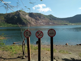
Taal Volcano may be small but it is considered as the smallest active volcano in the world. It is located in Taal lake which is the third-largest lake in the Philippines located in Batangas and home to the Vulcan point island. It is described as an island within a lake within an island, within a lake in an island, it may sound confusing but that's how complicated it's order. Contrary to popular belief, some may have thought Mt Binintiang Malaki and Mt Balantoc (the most prominent landmark as viewed from Tagaytay) as Taal volcano which is completely wrong.
We visited Taal volcano via Tabaro trail almost 2 years ago since we prefer to see the crater lake up close. If you to visit Taal volcano via the Tabaro trail, boat ride starts from
San Nicolas, Batangas where one can see the
Alas-as Bird Sanctuary; home of migratory Egrets and the dry lava field. According to our local tour guide, Mt Tabaro's crater was formed during the 1965 phreatomagmatic eruption. The trail starts from a established pathway that passes numerous rock formations that were formed from lava gully, most were black color that signifies rich in Iron mineral. The trail continues until reaching a sandy part filled with ashes which then leads to Mt. Tabaro, it was a backtrail and so we decided to head towards the crater lake of Taal. In order to reach the crater lake, one has to ascend a 340ft trail composed of sandy and ashes, then descend to 360ft to reach the crater lake.
Throughout history, Taal volcano has 34 recorded explosions since 1572 including the recent (January 12, 2020). According to Philvocs, 1754 and 1911 may have been the most devastating eruption. According to the book
The Mysteries of Taal, 1991 written by Thomas R. Hargrove, "Taal Lake was Salt Water prior to 1754. The huge 1754 eruption that lasted for 6 months from May to December 1754 changed the salinity of the water from salt to fresh water. It sank 5 Batangas towns formerly located along the shores like Tanauan, Taal, Lipa, Bauan and a lost town that was never revived named Sala. Because of that tragic eruption, the map of Batangas was drastically changed so you have to respect and adjust with nature and learn from its violent history."
I would describe the crater lake as so blissful and serene but at the same time, dangerous where it constantly smells sulfur due to its volcanic activity.
 |
| Taal Volcano crater lake |
 |
| Taal Volcanic Island |
 |
| Mt Tabaro on the background |
 |
| Photo credit: Joen Panado |
 |
| Black ashes/sand as a prominent part of the trail |
 |
| Bird sanctuary for Egrets |
 |
| Mt Binitiang Malaki & Mt Balantoc often mistaken for Taal Volcano |
***I joined an event organized by John Sarco
** Some excerpts were taken from Marra Zambrano's post (The Mysteries of Taal, 1991 written by Thomas R. Hargrove)


