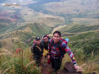
Mt. Balingkilat is one of the highest peaks in the Zambales coastal mountain ranges and coves area which stands at an altitude of 3600 ft. above sea level. American naval servicemen who once served in Subic Naval Base used to call it as the “Pointed Peak” but the indigenous people (Aetas) prefer to call it as Mt. Balingkilat which means "Mountain of Thunder".
Since our hike was a planned traverse to Nagsasa Cove, we started the trek at 3am (traverse time is 12 to 13 hours and is usually an overnight hike, we finished it in 11.5 hours as a day hike). The first part of the trail is composed of grassland (overgrown "Talahib" and "Cogon" grass are present throughout the trail). After an hour of trek one will reach the only tree in the midst of the grassland which marks the start of the assault. The assault trail is more or less 2600 feet in altitude gain which has a lesser grass and is predominantly a rocky portion. It becomes very steep in the final 600 feet before the summit where it requires technical climbing skills through rock walls and boulders with almost 90 degrees vertical climb.
Upon reaching the summit one will be rewarded with a 360 degree picturesque view of Zambales mountain ranges: Mt. Cinco Pincos and coves: Anawangin, Talesayen, Nagsasa, and Silanguin Cove. Mountains in Bataan can also be seen from afar: Mt. Natib, Mt. Samat and Mt. Mariveles. Since we were greeted by Typhoon Marce during the climb, the summit was covered with mist and clouds, thus a 360 degree was not possible.
After our short rest, we decided to resume the traverse-descent to Nagsasa cove and were overwhelmed by a strong gush of wind (60 to 70 kph) through a very steep and slippery rocks that passes through ridges and ravines. The clouds that enveloped the whole mountain ranges prevented us from seeing the beauty of the traverse trail, but then again it was still a blessing in disguise if it were not for Typhoon Marce we could have been "toasted" under the scorching heat of the Sun, because there is zero trees cover. The rain also made us extra careful, thus practicing extreme precaution knowing that danger is imminent especially during a typhoon surge.
As we approached the final leg of the traverse trail we were glad that there was a "clearing" in the view, enabling us to see the vastness of the South China Sea, coastline of Nagsasa Cove and the nearby ridges. We took some time to take souvenir pictures and thanked God that we reached Nagsasa cove safe and sound.
How to Get There:
1. Ride a bus bound to Iba, Zambales (Victory Liner) and tell the conductor to drop you off in PNP Station of Subic. You also need to prepare a letter of intent before you can start your hike which will be submitted to PNP Subic.
2. Then ride tricycle going to Sitio Cawag, Mt. Balingkilat’s jump off point.
(I joined an event organized by the Adventurous People)


Sobrang init dyan sir wla kasing puno.
ReplyDelete